Ferris Fire Update July 9: Fire Grows to 60,105 Acres, 19% Contained as Crews Strengthen Lines and Evacuations Remain in Effect
Description: The Ferris Fire has burned 60,105 acres and is 19% contained as of July 9, 2026. Firefighters continue strategic firing operations, direct attacks near Benchmark Lookout, and strengthen containment lines while evacuation orders remain in place across Dolores and Montezuma counties.
Ferris Fire Update
Thursday, July 9, 2026
Email: 2026.ferris@firenet.gov | Phone: 661-990-4727
Acres: 60,105 Containment: 19% | Reported: 06/27/2026
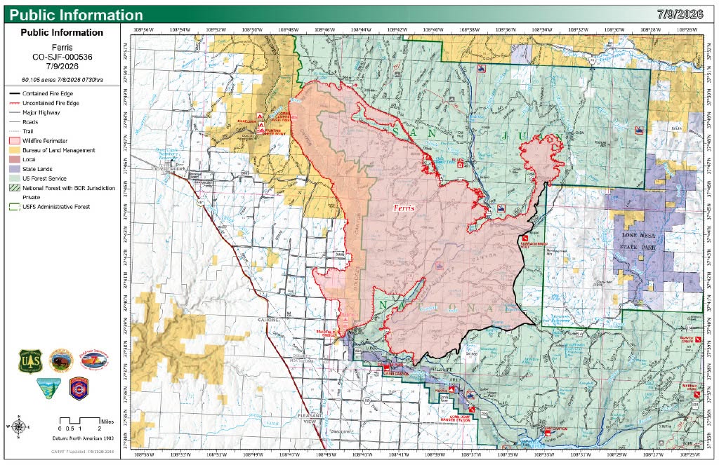
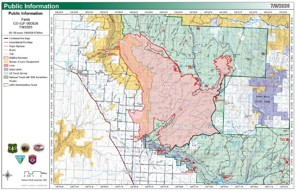
Yesterday was another day of active fire behavior, with the most significant activity occurring along the western portion of the fire. Despite the challenging conditions, firefighters continued to make progress building, improving and securing control lines across the fire area.
The southwest corner of the fire, between Dolores County roads M.4 and S, continued to experience periods of intense fire behavior. Crews worked to secure the fire’s edge from Dolores County Road M.9 south toward Bradfield Bridge Campground. Fire has reached the campground; however, no structures have been impacted. Two hotshot crews, numerous fire engines and an unmanned aircraft system (UAS) module used strategic firing operations along Forest Road 521 to remove unburned fuel between the fire and the roadway in a slow and controlled manner.
Crews made good progress strengthening the primary fireline on the west side of the fire, from east of the solar fields along Dolores County Road M.4 north to Dolores County Road H.6. Burnout operations have been very successful, and firefighters have mopped up portions of the line 75 to 100 feet inside the fire perimeter. This will reduce the potential for the fire to rekindle near the control line.
The northwest corner of the fire, on the east side of Dolores River Canyon north of Glade Canyon, remained challenging due to rough topography and active fire behavior. The fire made runs through Big Spring Gulch and Glade Canyon but remained within the retardant lines that were placed on the rim during the operational period on Tuesday. In the Dolores River Canyon, the fire continued backing and flanking within the canyon but did not make any significant uphill runs to the rim. Firefighters continued prepping along Forest Road 220 using dozers in addition to scouting and constructing additional indirect fireline in that area.
Fire behavior on the north side of the fire, from the junction of the powerline and Forest Road 504 east, remained moderate. Firefighters continued securing the road system where burnout operations were completed Monday. That line continued to hold and is in good condition.
Lower fire intensity in the northeastern portion of the fire around Benchmark Lookout, allowed firefighters to engage the fire directly. Air tankers dropped retardant on the fire’s edge while hotshot crews constructed handline, removing vegetation ahead of the fire to limit its spread.
The eastern edge of the fire from Benchmark Lookout south remains secure. Yesterday, crews focused on mopping up, holding and improving the existing lines to increase their depth and strengthen containment.
Evacuation Zones 1, 2, 7, 8, and 10 are all in “GO” status. Visit the Dolores County interactive evacuation map for your zone. Zones 3, 5, 9, 12, 13 and 14 are all in “SET” status.
Today’s Operations: In the southwest corner, near Bradfield Bridge Campground, crews will continue using forest roads 504 and 521, along with natural features, as the primary control lines. When conditions allow, firefighters will conduct strategic firing operations to remove unburned fuels between the fire and these control lines to limit fire spread to the south. Along the western edge of the fire, personnel will continue monitoring, holding and improving control lines.
In the northwest corner, on the east side of Dolores River Canyon north of Glade Canyon, where terrain does not allow for direct attack, firefighters will continue constructing indirect line ahead of the fire. On the northern edge of the fire, firefighters and engines will patrol the existing line, extinguish any hot spots and respond quickly to any areas of concern. Crews in the northeastern section, around Benchmark Lookout, will continue direct line construction. Fixed and rotor-wing aircraft will support ground resources with retardant and water drops as needed.
Weather: Temperatures are forecast to be hot again today, rising into the upper 80s with relative humidity falling to around 10 to 15 percent. Thunderstorm chances decrease today, but gusty, erratic winds remain a threat from distant storms. Outside of outflow, winds will generally come from the west at 12 to 30 miles per hour. No appreciable rainfall is expected this week, although there is potential for wetting rains next week.
Personnel: 658 personnel are assigned to the Ferris fire.
Evacuations and Closures: Both Dolores and Montezuma Counties have active evacuation orders in place. An interactive evacuation map is available at: https://tinyurl.com/FerrisFireEvacMap. For current information see the Dolores County Office of Emergency Management Facebook page. The San Juan National Forest has a Fire Area Closure in place as does the Bureau of Land Management for Bridge Recreation Area and multiple roads on the north end of the Ferris Fire.
NO DRONE ZONE: Private aircraft, including drones, are not allowed over the fire or McPhee Reservoir. A Temporary Flight Restriction (TFR) is in effect over the fire area.
Smoke Information: East winds in the morning will shift west by the afternoon with the inversion breaking around noon. This will allow the smoke to lift and move off to the east. Despite visible smoke, near-ground levels of air quality in locations near the Ferris Fire remained GOOD overnight into this morning.

.png)