.png)

Aspen Acres Fire Holds at 61% Containment as Crews Strengthen Lines Near Rye
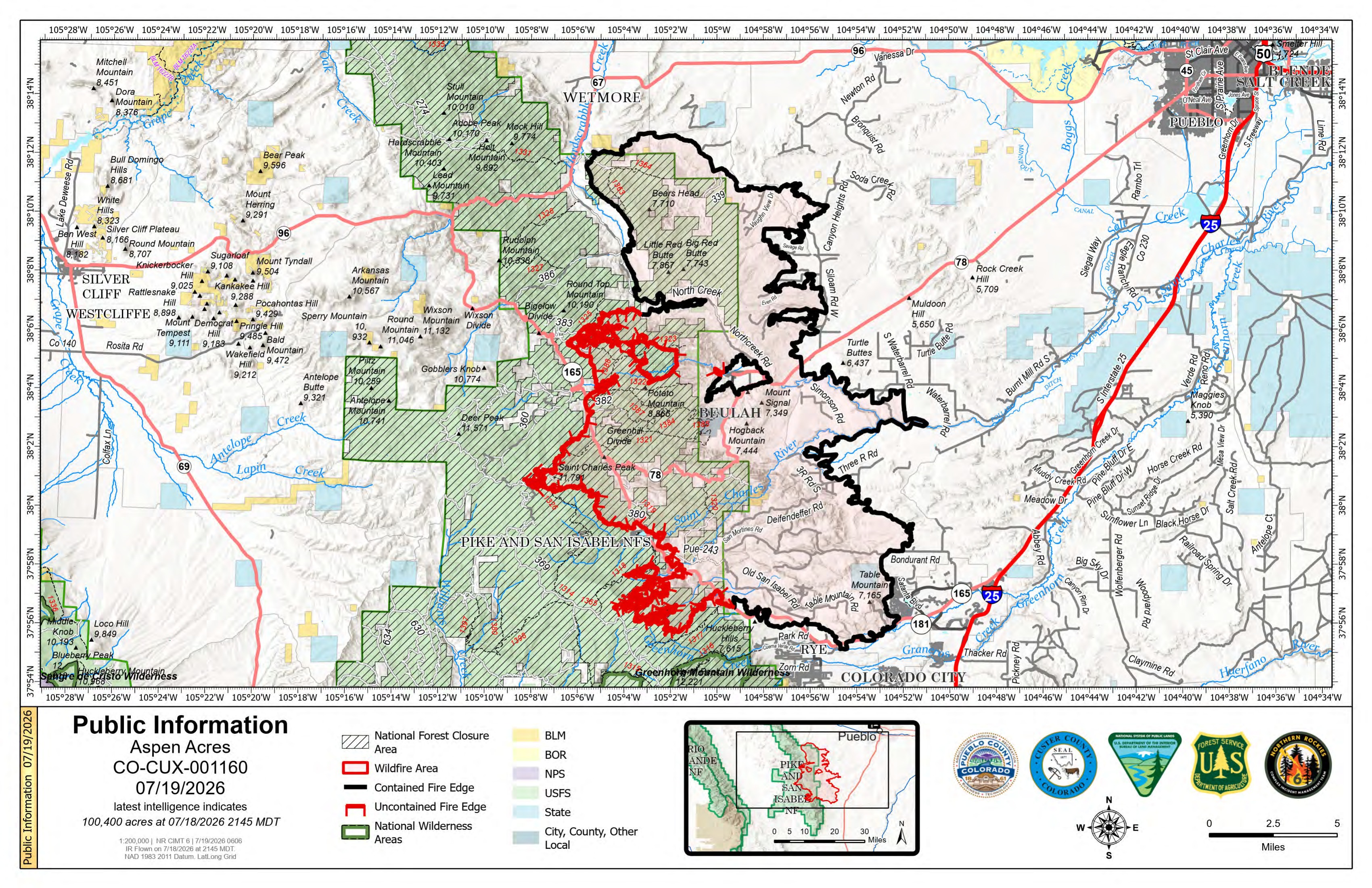
Description: The Aspen Acres Fire is officially 100,224 acres and 61% contained as crews conduct firing operations near Lake Isabel and reinforce firelines above Rye...
Daily Update for the Aspen Acres Fire for 7/19/2026
Start Date: Reported 06/29/2026 around 6:00 a.m. Cause: Human, Under Investigation
Official Acreage: 100,224 acres Latest Intelligence: 100,400 acres
Containment: 61% Total Personnel: 1,566
NOTE ON ACREAGE
How acreage is being reported has changed. Official reported acreage will be listed at the top of the daily update, followed by latest intelligence from nightly infrared (IR) flights. Mapping will continue throughout the day to confirm the latest intelligence acreage and, if confirmed, will be reported as the official acreage in the following day's update.
KEY MESSAGE
On Saturday, firefighters continued successful firing operations on the west side of the fire near Lake Isabel and Little Saint Charles Creek, reducing areas of fuels between the active part of the fire and the primary control line. The firing operations resulted in visible smoke columns as firefighters worked to strengthen control lines. Visible smoke from tactical firing operations is expected to remain in the following days. Ground operations were supported by aerial assets, including four super scoopers and seven Type I helicopters. Aerial firefighting resources were able to deliver water to areas of heat on the southwest side of the fire, above the community of Rye, preventing fire spread to the south and east.
Several additional Interagency Hotshot and Type 2 hand crews are joining the Aspen Acres fire to assist in ongoing firing operations on the west and southwest perimeter of the fire. In the vicinity of San Isabel Lake, fire personnel will take advantage of slope driven fire spread and weather conditions to strengthen defensive lines today. In Division B, which has been referenced previously as the 'chicken foot', hand crews are using Millset Ridge as an anchor point for defensive line. Aerial assets will continue to support ground crews during the day by delivering water to the fire area and extinguishing areas of heat above Rye, keeping fire north and east of the primary control line. Unmanned aerial systems (UAS) will support firefighters with reconnaissance footage and infrared imaging during the night if conditions allow.
Night shift is patrolling the control lines, monitoring and responding to any fire activity close to the fire lines. A third shift, or 'swing shift', of firefighters will begin this evening to provide continuity of operations between day shift and night shift, to strengthen the transition between day and night fire behavior.
Heavy machinery and hand crews are working in tandem north of Round Top Mountain and the Mingus Ranch area to reduce future erosion concerns. These ground resources, assisted by UAS and aerial firefighting operations, are continuing to eliminate lingering hot spots. Crews made progress on fence repair and mop up along the eastern perimeter of the fire footprint. On the north and east edge along containment lines, the crews are continuing mop-up and initial repair work to stabilize the landscape.
For public and firefighter safety, please stay out of active fire areas so firefighters and heavy equipment operators can continue work without added risk.
WEATHER AND FIRE BEHAVIOR
Yesterday, a thunderstorm moved over the fire area, dropping 0.015 inches of rain on the west side, bringing with it outflow winds with up to 25 mph gusts. Despite the storm-related winds, fire activity remained moderate with short crown runs through trees and single tree torching.
Warm dry weather is expected to continue through Monday, bringing temperatures of 78-82 degrees the fire area with 23-27% humidity and easterly winds during the day with gusts of up to 24 mph. Fire spread rates are expected to increase in areas of dry grass and brush ,increasing likelihood of burning. Expect to see increased fire activity in areas of high spruce mortality. Fire behavior will be most influenced by terrain-driven wind where the slope and wind align.
AREA CLOSURE
There is an Aspen Acres Fire Area Closure for the San Carlos Ranger District. Visit: https://www.fs.usda.gov/r02/psicc/alerts/aspen-acres-fire-area-closure. Please monitor land managing agencies for other fire restrictions. The National Forest Lands are closed and are also in evacuation status.
There is a Temporary Flight Restriction (TFR) in place above the fire area. Flying any aircraft within the TFR is prohibited. This includes the use of drones, or unmanned aerial systems.
EVACUATIONS
Area C-9B was adjusted back to pre-evacuation status on Saturday at 9am. Wetmore and Greenwood areas remain in pre-evacuation status. The area from Mackenzie Junction Highway 165 south to South Hardscrabble Road opened for residents with Rapid Tag re-entry cards on Friday. Other areas of Custer County affected by the fire remain in pre-evacuation and evacuation status. For Custer County re-entry questions or specific evacuation status, call 719-467-0271.
In Pueblo County, evacuation status has been lifted for the north and northeastern portions of the Aspen Acres Fire perimeter. Residents south of Highway 96 and north of Highway 78 are allowed to return to their homes. All residents will remain in pre-evacuation status and must be prepared to leave should conditions change. Evacuation status remains on the south side of the fire, with Colorado City remaining in pre-evacuation status.
Huerfano County Sheriff's Office returned all Forest Service land North of CO-69 to the northern-most Huerfano County line to Pre-Evacuation Notice. This includes CR 630 North of CR 630.1 and CR 634 North of 634.2, as well as the entirety of the Greenhorn Wilderness Area. For further information, call 719-738-1044 to reach Huerfano County dispatch.
An awareness status is in place for Fremont County, encouraging residents to stay informed, monitor official updates, and remain prepared.
AIR QUALITY
An Air Resource Advisor is assigned to the incident and assessing where communities may be impacted by smoke. To get daily air quality information, visit https://fire.airnow.gov/
OFFICIAL WEBSITES
The public and members of the media should monitor the following official websites:
Follow Pueblo County Sheriff's Office Facebook at www.facebook.com/PuebloSheriff
and X: @PuebloCountySO https://x.com/PuebloCountySO.
Follow Custer County Sheriff's Office Facebook at https://www.facebook.com/CCSOAdmin.

Image Gallery