.png)

Gold Mountain Fire Update July 28: Fire Mapped at 39,506 Acres, 50% Contained as Flash Flood Risk Continues
Description: The Gold Mountain Fire near Ouray, Colorado is now mapped at 39,506 acres and 50% contained. Officials say the increase reflects updated mapping, not new fire growth, as firefighters continue suppression repair and warn of flash flooding.
Fire Update – Gold Mountain Fire
Tuesday, July 28, 2026 – 8:00 a.m.
Rocky Mountain Complex Incident Management Team 1
Justin Conrad, Incident Commander
Information Phone: 970-355-3286
Email: 2026.goldmountain@firenet.gov
Information Staffing Hours: 8 a.m. to 8 p.m.
Safety Message: Scattered and isolated storms have the potential to produce lightning, strong winds, and heavy rain. Burned areas neighboring the US 550 corridor in Ouray County are especially vulnerable to flash flooding, debris flows, and falling rocks during these events. Firefighters and the public should remain alert and use caution when traveling in and around this area, especially during and after storms. Forest Service Road 864 and 858 remain closed south of Cimarron due to heavy equipment operations, debris removal, and ongoing firefighting. Please avoid this area to ensure personal safety, safety of fellow travelers, and that of firefighting personnel.
Current Situation: Acreage and containment have increased due to updated mapping and modeling, providing a more accurate picture of the fire’s interior footprint. The purpose of this is to assist with tactical decision making and does not correlate to growth of the fire’s external perimeter and previously achieved containment. Fire activity remains low throughout the Gold Mountain Fire.
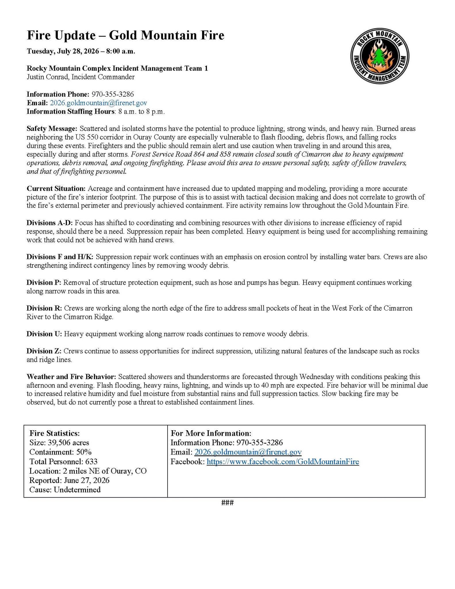
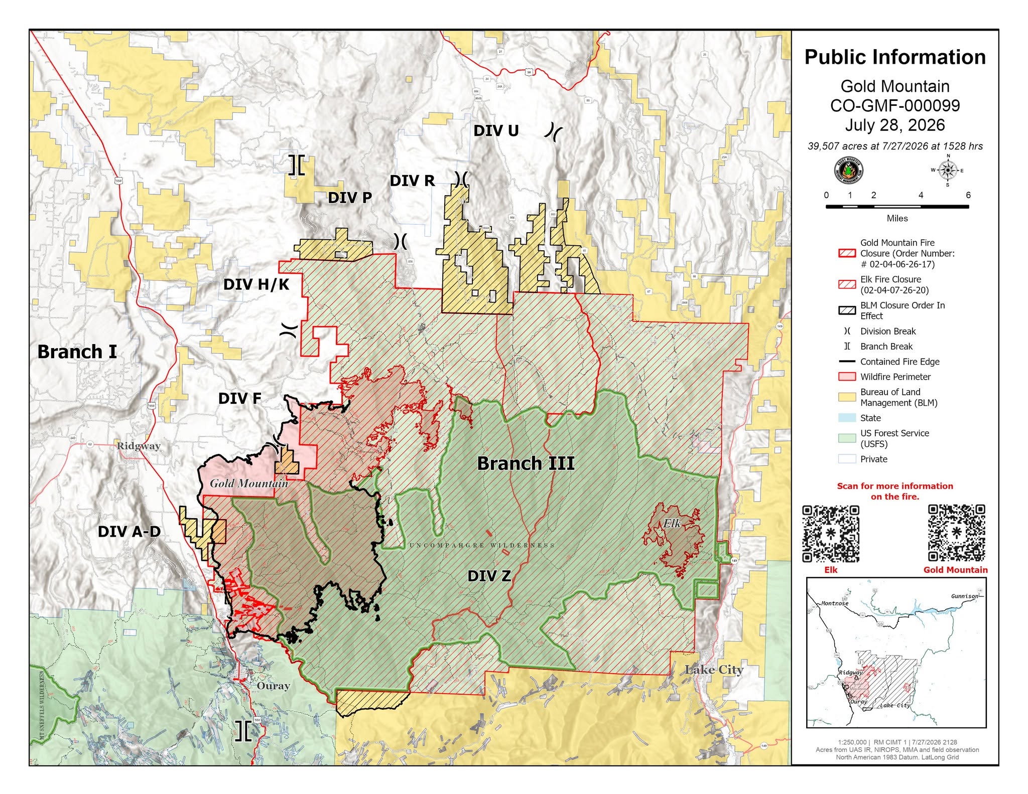
Divisions A-D: Focus has shifted to coordinating and combining resources with other divisions to increase efficiency of rapid response, should there be a need. Suppression repair has been completed. Heavy equipment is being used for accomplishing remaining work that could not be achieved with hand crews.
Divisions F and H/K: Suppression repair work continues with an emphasis on erosion control by installing water bars. Crews are also strengthening indirect contingency lines by removing woody debris.
Division P: Removal of structure protection equipment, such as hose and pumps has begun. Heavy equipment continues working along narrow roads in this area.
Division R: Crews are working along the north edge of the fire to address small pockets of heat in the West Fork of the Cimarron River to the Cimarron Ridge.
Division U: Heavy equipment working along narrow roads continues to remove woody debris.
Division Z: Crews continue to assess opportunities for indirect suppression, utilizing natural features of the landscape such as rocks and ridge lines.
Weather and Fire Behavior: Scattered showers and thunderstorms are forecasted through Wednesday with conditions peaking this afternoon and evening. Flash flooding, heavy rains, lightning, and winds up to 40 mph are expected. Fire behavior will be minimal due to increased relative humidity and fuel moisture from substantial rains and full suppression tactics. Slow backing fire may be observed, but do not currently pose a threat to established containment lines.
Fire Statistics:
Size: 39,506 acres
Containment: 50%
Total Personnel: 633
Location: 2 miles NE of Ouray, CO
Reported: June 27, 2026
Cause: Undetermined
For More Information:
Information Phone: 970-355-3286
Email: 2026.goldmountain@firenet.gov

Image Gallery